Conflict, controversy haunt K-Beach flooding solutions
Published 4:47 am Sunday, September 20, 2015
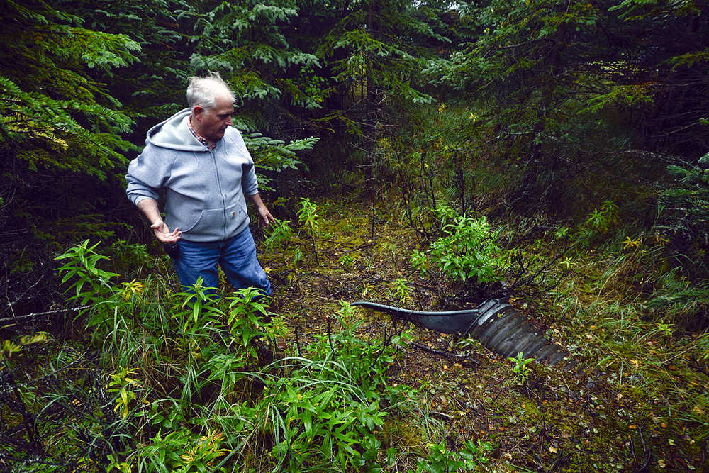


With rubber boots up to his knees and only a gray sweatshirt to protect him from the cool drizzle, Dan Sterchi crashed through waist-high weeds to the base of a muddy bluff to peer up through the trees.
“See that culvert?” He pointed up the steep side of the bluff toward a small, corrugated metal pipe peering between the trees. “During breakup, that thing spews water clear down to here.”
He indicated the metal sea walls that edged up to his property, just to the north of where the pipe pointed out toward Cook Inlet. He and his neighbor built the sea walls to protect their homes from erosion, he said, because when high water courses through the Kalifornsky Beach area, the ground becomes marshy with groundwater. During an earthquake, the bluff “turns to soup,” he said. Added to the more than two feet of erosion from Cook Inlet every year, the sea walls that line the entire bluff make sense.
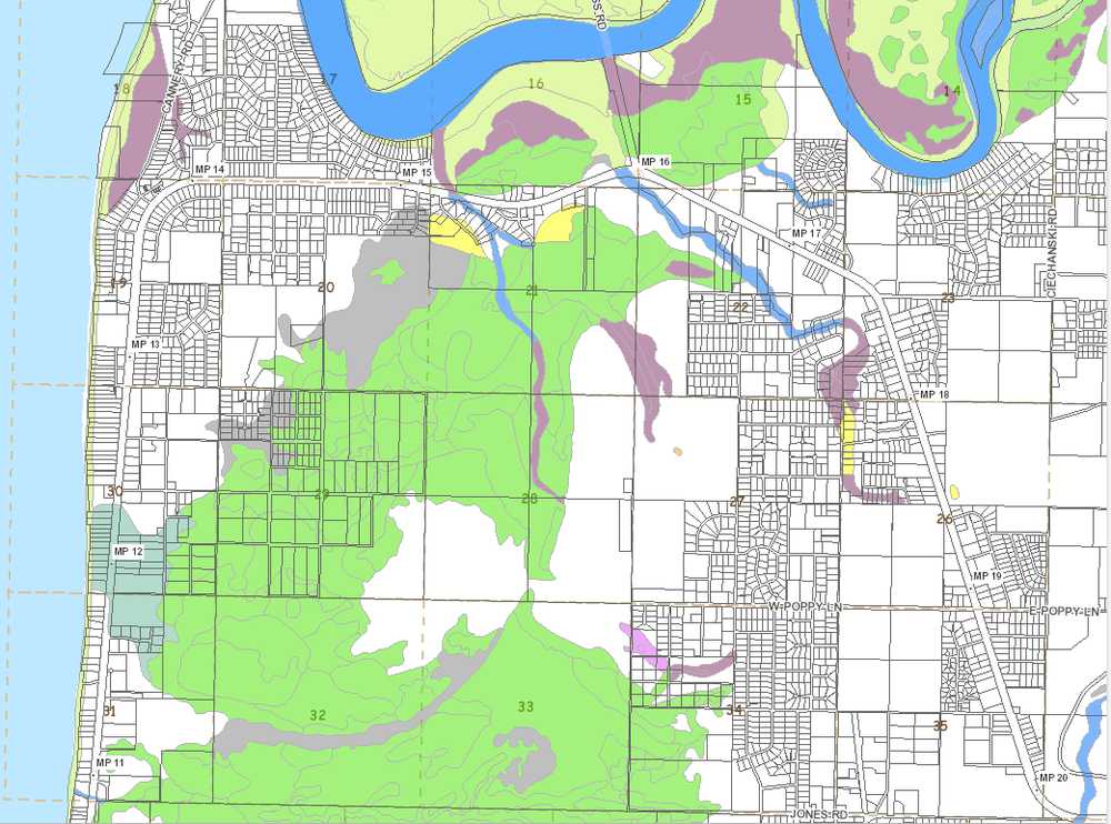
The stretch of land between Kenai and Kasilof on Kalifornsky Beach Road has been a frequent topic of discussion since October 2013, when floods inundated the area and threatened hundreds of homes. The state declared a disaster, the Federal Emergency Management Agency designated $1.26 million to help with recovery and the borough government has been batting around solutions since.
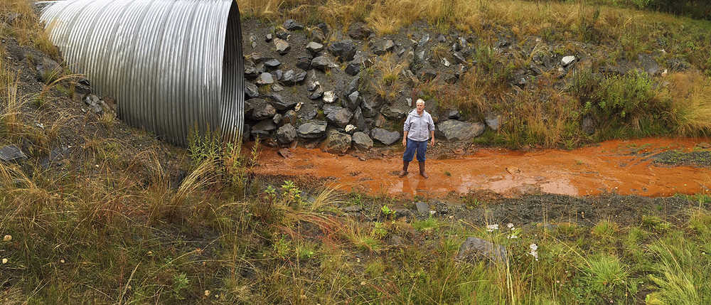
Part of the plan currently on the table is to exchange a piece of property known as the Karluk Basin, owned by Paula and Timothy Keohane, with the 1.8-acre parcel next to Sterchi’s property, where the drainage pipe lies. During the flooding in 2013, the borough pumped water out of the Karluk Basin and into Cook Inlet. Borough officials determined it to be a critical drainage location and offered to buy it from the Keohanes.
However, the Keohanes refused to sell. The borough later negotiated to trade a piece of land for the section of the property that contains the basin. From several pieces of property offered to them, the Keohanes chose the beachfront parcel.
The borough is currently in negotiations to trade the parcels, maintaining a 60-foot easement for the pipe as drainage. The Kenai Peninsula Borough Assembly is due to vote on the exchange Oct. 13.
However, some have said the land trade would leave the borough with one less viable drainage option. Sterchi submitted multiple public comments to the assembly, imploring them not to go forward with the exchange and asking assembly members to visit the property to see it for themselves.
It may be a “much bigger tiger than it appears in the ordinance,” according to Stan Welles, the KPB assemblyman who represents the Sterling and Funny River area. Welles, a former aeronautical engineer, took Sterchi’s invitation to walk the property to see what the borough is proposing and brought back several concerns about the land trade.
Welles wrote that the installation of a pipe big enough to handle the drainage would likely take up the entire property. Although pumping water to the Keohane property helped alleviate the flooding in 2013, it is not a long-term solution for the area, Welles wrote.
The land near K-Beach Road is relatively flat, rolling slightly downhill toward Cook Inlet. Traced with tracks of natural drainage, the land used to take care of its own water excess. Sterchi, who has lived in the area more than 30 years, said he remembers when much of the area was an undeveloped wetland.
“Everybody knew it was a lake back here,” Sterchi said. “Now it’s been dry for 10 years. Now there’s white spruce growing where swamp spruce used to grow. But it doesn’t have to necessarily stay dry.”
On many of the plats in the K-Beach area, there are surveyors’ lines that read “subject to inundation” on parts of properties, or notes that read “drainage and/or fill will be required for development as the water table is near the surface.” The wetlands map indicates that swathes of it are indeed a lakebed and upland drainage across Mile 12 of K-Beach Road and stretching northeast from the beach.
However, some of the areas that experienced flooding in 2013 are not in the area defined as wetlands. The sand aquifer that underlies the area filled up with the nearly 18 inches of rain that fell between July and October 2013, about 8 inches more than average, said Jim Munter, a former state hydrologist and co-chair of the K-Beach High Water Drainage Task Force, a citizens’ group that organized to develop solutions to future flooding in the area. The aquifer couldn’t absorb any more water, which led to surface flooding.
Although draining water from the Karluk Basin worked temporarily, the solution was neither long-term nor widespread, Munter said.
“It’s like a Band-Aid on a major artery wound,” Munter said. “It may have partially alleviated the worst of the flooding, but the scale of it I don’t think really changed the picture for very many people.”
Using the basin as permanent drainage infrastructure contradicts borough code as well, Welles said. The code states that when building drainage, the flow of water should be directed toward “natural drainage courses, ditches or waterways, or other man-made drainage courses, to prevent excessive siltation of riparian habitats, erosion, or damage to public and private property.”
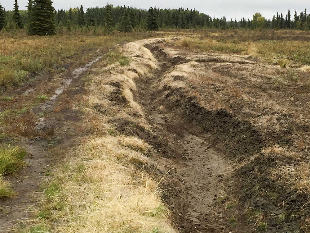
Along Buoy Avenue, about a half-mile south of the Karluk Basin, the borough constructed a 9,000-foot ditch that serves as a drainage gallery, where water is meant to collect and eventually dissipate into the ground. A long ditch on the east side of K-Beach Road also collects water.
However, Sterchi said the ditches could overflow if the area floods again, and runoff could weaken the roads. When heavy precipitation washed out K-Beach Road at Mile 11 in September 2012, the water took a huge section of road with it into the ocean and created a ravine approximately 300 feet wide and 34 feet deep.
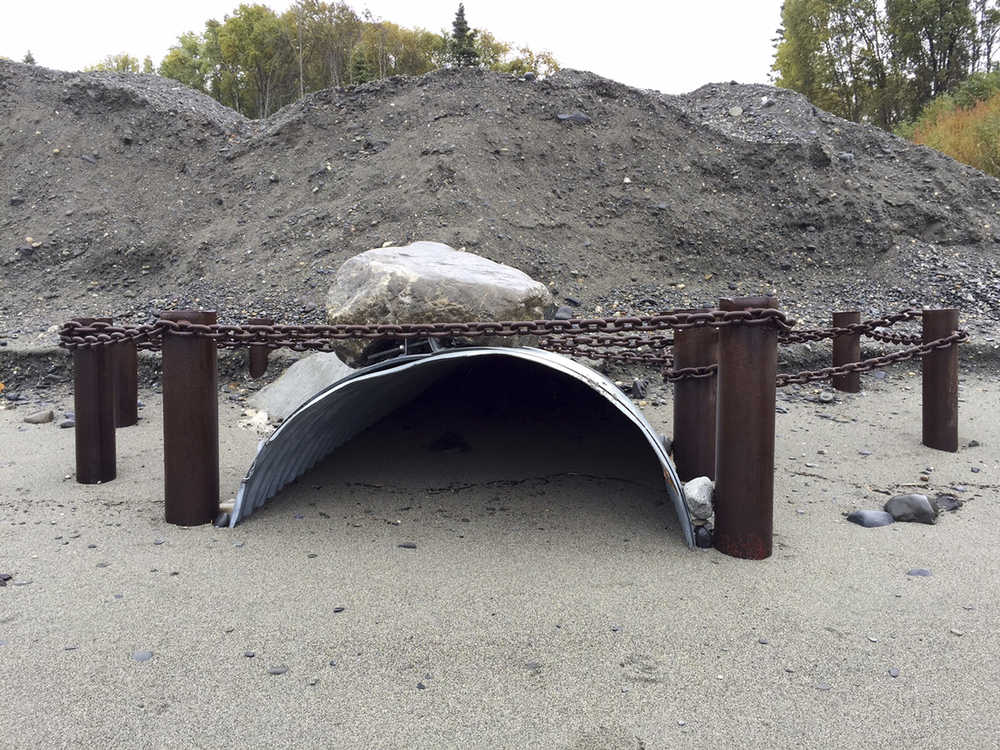
In response, the Alaska Department of Transportation put in a 12-foot culvert, more than twice the size of the proposed culvert at Mile 12, to deal with the future drainage, at a cost of more than $1 million. This was the second time the state had repaired the road — K-Beach Road washed out at the same place in 1990.
Draining the water clear through to Cook Inlet, like what Sterchi and Welles suggest, may not be an option either. Borough records show that although it once owned more than 100 properties on the west side of K-Beach Road, it has gradually sold off 91 parcels, leaving it with only 18 between mile 4 and mile 16 of K-Beach Road.
Only four are within three miles of the Karluk Basin. One, on the corner of Jacobs Street and K-Beach Road, is close but does not touch the inlet to allow for a culvert to run through on borough land. Another does reach through to the inlet, but is located at Mile 10.5, more than a mile and a half from the Karluk Basin. A third that does touch the inlet is even further, located at Mile 10.
The last is the property adjacent to Sterchi’s.
There are relatively few drainage pipes that go through to the other side of K-Beach Road. Most of the land is now privately owned, and the records of the easements that do exist are hard to find. Ann Shirnberg, the administrative assistant for the Land Management Department, said in an email the borough does not maintain easements that exist along K-Beach Road, saying the DNR maintains them.
However, DNR records show no easements along that road. DNR Public Information Officer Kathy Johnson said the borough would grant and maintain the easements along that road. The Department of Transportation also does not maintain records of easements along that road, according to DOT Central Region spokesperson Jill Reese.
Wherever the easements are, there are some culverts that exist, but they follow no formal plan of a stormwater drainage system in the area. Sterchi expressed concern that if the borough moves forward with the six-foot culvert and does not plan long-term, the next washout could take his and his neighbors’ houses with it.
He said he remembers a spring breakup when vast amounts of water raced down his neighbor’s driveway that ran to the beach and eroded a large section of the bluff.
“That was when the seawalls started going up,” Sterchi said. “It’s do that or lose your house.”
Immediately after the floodwaters started receding, the borough was faced with the question of who was responsible for paying for the long-term strategy.
If this was a one-time event, should the borough simply hold off and work with an emergency drainage system? Or should it plan for this to happen more frequently and invest in a comprehensive drainage structure?
“I don’t think it’s responsible public policy to drain a wetlands,” said Kenai Peninsula Borough Mayor Mike Navarre. “We have authority over roads, not drainage. We’ve done everything we reasonably can and I think we’ve been responsible about that.”
Navarre said the 2013 flood was the first time something so drastic has happened, and it was a combination of heavy summer rains and warm temperatures that dragged on into October that led to the flooding. Planning for frequent flooding, then, is an unnecessary expense because it’s unlikely to happen to such an extent again.
Instead, the drainage galleries installed on Buoy Avenue and the culvert in place at Dog Fish Avenue can handle the excess water, allowing it to percolate into the water table and drain out through natural seeps, he said.
The push for a comprehensive drainage system is partially from those who have a vested interest in having the wetlands drained, said Paul Ostrander, the mayor’s chief of staff. Some residents built in areas that were known floodplains and would stand to gain property value if they were no longer at flood risk.
“If you look at the plats, there are clear lines that say ‘subject to inundation,’” Ostrander said. “You have to look at who would stand to gain from a comprehensive drainage system and draining the wetlands.”
Navarre said the easement that comes with the Karluk Basin and the other projects the borough has installed can handle the normal high water table overflow. Other projects are still in discussion, but Navarre said he is not sure if they are necessary.
The K-Beach High Water Drainage Task Force, however, continues to suggest projects. When they proposed a feasibility study that would provide a comprehensive view of the entire K-Beach area, they ran into a problem with funding from the state. When they proposed a drainage ditch along Seventh Avenue, they were told they needed permission from all the landowners, one of which is the borough. The complications of obtaining permission from all the landowners put the project on hold, Munter said.
Munter said the borough has evaded hiring an engineer to complete designs for the drainage in the area. However, Navarre said the borough has had civil engineers examine all the drainage in question and design the drainage ditches, such as the one on Buoy Avenue. Navarre said the DNR never recommended that the borough hire a drainage engineer, although Munter said the DNR verbally recommended that the borough do so.
The DNR has been uncharacteristically hands-off with enforcement of the borough’s water diversion as well, Munter said. The K-Beach High-Water Drainage Task Force sent a letter to DNR Commissioner Mark Myers in April, saying that the DNR has repeatedly chosen not to enforce permits against the borough and asking for stronger enforcement.
DNR Chief of the Water Resources Section David Schade, who has worked with the task force and the borough on permitting, did not return a request for comment.
The land trade is a reservation in case of a return of the flooding, not intended to be a permanent drainage structure, Navarre said. By trading the land, the borough gains a permanent easement in the Karluk Basin and retains a 60-foot easement for drainage on the parcel on the bluff. The proposed ditch for the Seventh Avenue, by comparison, is 20 feet, so 60 feet should be enough, Navarre said. A civil engineer has examined the area and the borough’s water resource manager, Dan Mahalak, is working on flow studies for the area. The borough also plans to obtain an official opinion from the Department of Transportation before the planned vote on Oct. 13, Navarre said.
There are no plans to install a larger pipe in the beachfront parcel at present. If the borough does decide to develop it in the future, they retained 100 feet to do so, Navarre said. The trade is simply because the borough needs access to that lowest-lying place in the Karluk Basin, where the water naturally flows, in case surface flooding happens again, he said.
Munter, on the other hand, said the flooding is more than likely.
“We can’t do anything about the rain,” Munter said. “The general consensus is that it’s going to flood again. My view is that a lot of the damage is avoidable.”
This is an opportunity to deal with a problem the borough has not addressed since it became a borough, Welles said. Though the original builders did not take the natural drainage channels in K-Beach into consideration, the borough has the chance to do so for the future.
“We should have had a drainage engineer on board decades ago,” Welles said. “To me, (the K-Beach Road blowout is) case in point; that illustrates the physical mechanism of what we’re setting ourselves up for if we don’t put this drainage in.”
Sterchi is adamant that the borough not pursue the land trade. He said that he has asked the borough every year if he could purchase the land and has been denied, told it was natural drainage. Now, for the borough to move forward with trading the land without having a comprehensive plan to use it as drainage is frustrating, he said.
“If they’re going to retain the 60 feet, then OK, sell the other piece to me so I can protect myself,” Sterchi said.
Reach Elizabeth Earl at elizabeth.earl@cmg-northwest2.go-vip.net/peninsulaclarion. Rashah McChesney contributed to this report.