
When Kenai’s airport rezone plan goes to the city council for a final vote, one measure will have the blessing of the Planning and Zoning commission and one will not.
On Wednesday, the commission approved the new airport light industrial zone and voted unanimously against zoning two properties bordering the Kenai Spur Highway as commercial. The Kenai City Council will take a final vote on both measures in the future.
Most Kenai airport property, encompassing 51 parcels, currently belongs to a “conservation” zone, which the airport light industrial zone will replace. Planning and zoning unanimously created the zone, but commission chair Jeff Twait and commissioner Kenneth Peterson voted against adding property to it because the rezone ordinance didn’t include buffer space between the neighboring residential zone on the airport’s southwest border.
The airport light industrial zone created to replace the conservation zone will permit most industrial uses, allow most commercial uses with permission from the Planning and Zoning commission, and ban most other uses. Under current conservation zoning, non-aviation industrial uses are prohibited and most commercial uses require permission. The new zone also makes aviation-friendly restrictions against dust, glare from building lights, and anything “that would foster an increase in bird population and thereby increase the likelihood of a bird-impact problem,” according to the zone-creating ordinance.
The rezoning plan is the work of the Kenai city administration, the airport commission, and planning and zoning. Kenai council member Henry Knackstedt started its creation at a May 6, 2015 city council meeting by moving to direct city administrators and the Planning and Zoning and Airport commissions to “research and provide recommendation to the City Council regarding the appropriate zoning for all Airport lands,” according to the minutes of the May 6 meeting. The council unanimously voted in favor. Results of the commission work were approved by the airport commission on Feb. 11.
At the time, Knackstedt said the rezone was necessary in part because “conservation” — a zone found almost entirely within the airport — has an ecological meaning that obscures the original context of Kenai’s conservation zone.
“When the city of Kenai initiated zoning, it designated all airport properties as ‘Conservation,’ meaning at the time that the land was conserved for the use of the Kenai Municipal Airport per the 1963 Deed,” Knackstedt wrote in a May 2015 memo supporting his council motion. The deed he referred to was the 1963 grant of airport land to Kenai from the federal government. “This zoning has been problematic since the meaning of the word ‘conservation’ has a different modern connotation which causes confusion, and because each lease or sale has required appropriate rezoning.”
Kenai resident and attorney Kristine Schmidt, wife and law partner of Kenai council member Bob Molloy, testified against the airport rezone, saying industrial uses could create noise and disruption in the neighborhoods west of the airport, which “depend upon these conservation-zoned lands to buffer them from the Kenai airport activity, noise, and pollution,” according to an email Schmidt sent the commission.
Although the vote to create the new zone was unanimous, the vote to add 48 airport properties to the new zone lacked the support of Twait and Peterson, who lives near the airport’s southwest border. Both were concerned about the lack of buffers near the airport’s border along Floatplane Road.
Kenai city planner Matt Kelley said the airport master plan, a set of development rules currently being updated by the airport commission, could contain buffer measures to protect airport-adjacent residencies.
Commissioner James Glendening said he believed the future final version of the airport plan would give sufficient protection to neighborhoods.
“I think the idea of mitigating noise, hazard, confusion, and disruption to normal civil life — I think that process is being carrying forward (in the airport plan),” Glendening said. He also noted that a light industrial zone already exists along the airport boundary, bordering the northern most block of the Floatplane Road neighborhoods.
The Airport Master plan is being written in three sections called phases. The plan’s completed phase 2, found on Kenai’s website, describes plans to purchase private land on the southwest side of the airport to serve as a natural barrier between neighbors and the airport’s conservation-zoned land. It also includes a $655,500 budget item for sound-dampening earth barriers, and $900,000 for fences. Phase 3 may contain further buffer measures.
Knackstedt said the three phases of the plan would be released for consideration by the city council sometime this spring. Kenai Airport manager Mary Bondurant said phase three of the airport master plan revision was given to a technical advisory committee on Feb. 2.
Twait said he would favor delaying the rezone decision until the commission knew what buffering provisions would be included in the master plan, “instead of us using a lot of supposition and assuming that it’s going to have the buffers we’re looking for.”
Glendening said he didn’t believe the city council would pass the rezone and the airport plan if the two did not collectively provide sufficient buffering.
“If we pass this as proposed, the two items can come together for approval by council,” Glendening said. “Council won’t approve this without consideration of the master plan… I’m satisfied that buffers for surrounding communities will be addressed.”
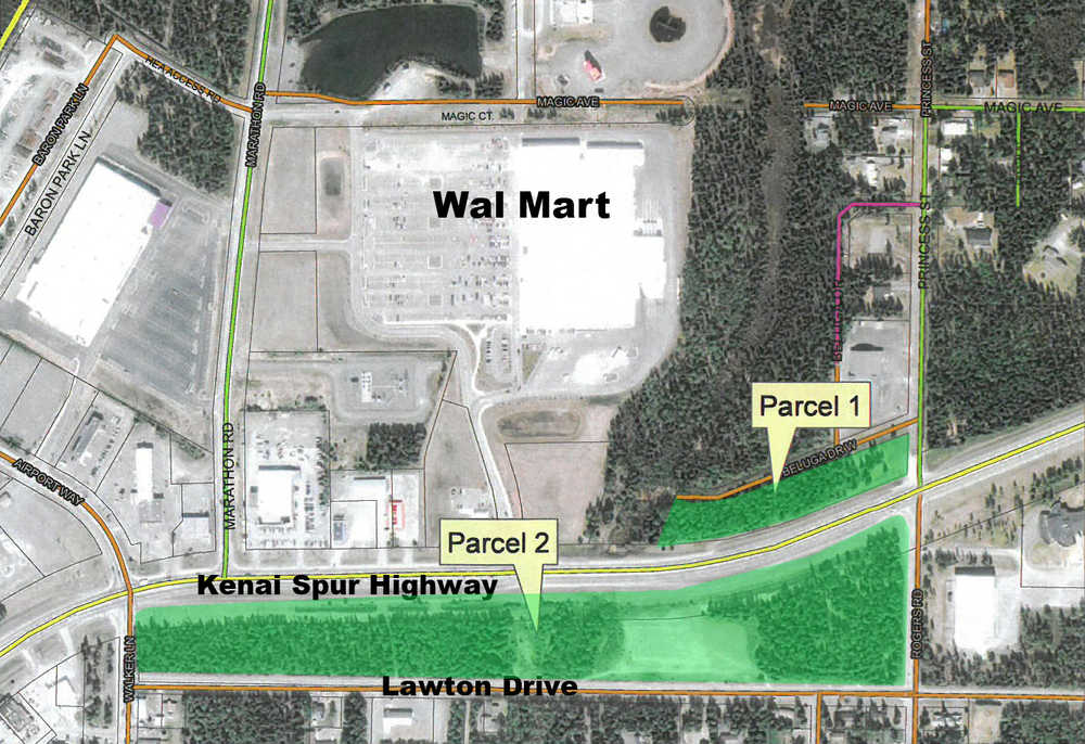
The woods between the Kenai Spur Highway and Lawton Drive, as well as a highway-front lot west of Walmart by the Kenai New Life Assembly of God church, are also in the existing conservation zone. The rezone plan would designate these two city-owned properties as general commercial zones.
Kelley said that if the 16.5-acre Lawton Strip was commercialized, its narrowness would make it more suitable to medical buildings and multi-story offices than commercial establishments requiring large parking spaces. He speculated that it could be divided into three commercial lots, of which he said that only the eastern and western properties would be easily developable because of a small creek between the Spur and the property, and the possibility of contaminated soil under the area currently occupied by the Field of Flowers. This plan would allow the Field of Flowers to be preserved.
The contentious rezone of the Lawton strip has been a cyclic debate. Various plans to commercialize it have been defeated by nearby residents since 1985.
In a memo to the commission, Kelley wrote that the strip’s history of deferred development began that year with a proposal to divide it into 29 residential lots, to be called Lawton Acres. At the time, the property was zoned suburban residential. Although Lawton Acres never materialized, the name is still sometimes used for the area. Kelly speculated in his memo that the property’s change the following year — from suburban residential to its present conservation zoning — may have been a reaction against the failed development. Nonetheless, commercialization attempts continued in 1985 with a proposal to build a Pizza Hut there. After public opposition, the rezone was defeated by a unanimous city council vote. Another failed commercialization proposal was made in 2005, and in 2013 it became a controversial part of the comprehensive plan that Kenai voters rejected that year.
The present iteration of the Lawton strip battle began with five Kenai residents opposing the rezone at Wednesday’s meeting: Schmidt, Bob MacIntosh, former Planning and Zoning Commissioner Roy Wells, and neighborhood residents Debbie Addison and Lucy Barton. Kenai Mayor Pat Porter also testified as a resident living near Lawton, supporting the rezone.
Though distant from the present Kenai airport, the Lawton and Spur properties were included in the original airport of the federal grant. Although the Lawton Strip is now a de facto buffer between residences and the Spur Highway, Porter pointed out that it still legally belongs to the airport and is subject to the 1963 grant, which states that “no property (of the Kenai airport) shall be used, leased, sold, salvaged, or disposed of by (Kenai) for other than airport purposes.” For land not directly needed by the airport, that purpose has been sale or lease for money to fill the airport fund.
“Remember, it needs to be sold or leased at a fair market value,” Porter said. “It’s not to benefit the citizens of Kenai. The way it benefits the citizens of Kenai is through sales or lease of land to support the airport, period. That’s it.”
Porter said it would be possible for the strip to remain a buffer if it became city or private property. Although airport lands are owned by Kenai, the FAA deed requires the city to “buy” them from the airport fund just as a private entity would. The city has made property purchases from the airport before, including the present sites of city hall, the library, and the Kenai animal shelter.
Schmidt, who moved to Kenai in 1982 and opposed previous efforts to commercialize Spur highway property, said talk of citizens purchasing the lot was not warranted, “because if you don’t rezone it, it just stays the way it is.”
When asked by Glendening how she would propose that the airport monetize the property, Schmidt challenged the reading of the FAA deed, saying it did not create a requirement to commercialize the land.
“I don’t think that airport land means that every inch of it has to be developed to the maximum,” Schmidt said. “I think that airport land can have some benefit to the citizens besides every inch of it being monetized.”
Although the Lawton strip was never legally designated as a park, two people living nearby — Barton and Addison — spoke to the commission about its value as a recreational green area.
“I’m just a resident who loves the look of the green of Kenai,” Addison said. “If you come from Soldotna, they don’t have that. It’s not the beautiful city that we have here. To think that we could lose that … it just seems like we should be working together to keep the beauty of this town.”
Former Kenai Planning and Zoning commissioner Roy Wells also spoke to the ordinance, saying that given the narrowness of the strip, its commercial value might be outweighed by its value as a buffer between the neighborhoods to the south and the traffic of the Spur highway and WalMart to the north.
“Until you really narrow this thing down, and have a better conceptual view of how it’s utilized, I think you ought to table it,” Wells said.
Glendenning asked Wells if he, as an individual or with a group of other citizens, would be interested in buying the property to preserve it as a buffer.
“If I could do it at a discount, because it’s been contaminated land,” Wells said. “I wouldn’t be buying it at normal value. … It ought to be a reduced price.”
The Lawton strip field, now a summer wildflower patch, was previously used by oil and gas companies to train employees in fighting chemical fires. The waste and debris left by those practice fires has since been covered with a hill of dirt excavated from Spur Highway enhancements and the construction of the Kenai Central High School football field.
Schmidt questioned the legitimacy of the Spur properties rezone plan, saying it went beyond the council’s intent in approving Knackstedt’s May 6 memo. In response, Knackstedt said the council had been kept informed of the airport and planning and zoning commission’s actions through reports by liaisons — himself for the planning and zoning commission, and council member Tim Navarre in the airport commission. Porter said she was also informed and approved the commission decisions.
“I was not blindsided by (the Lawton rezone) at all,” she said. She referred to language of Knackstedt’s memo, considering “appropriate zoning of all airport lands.”
“All airport lands means all airport lands,” Porter said. “Period. Nothing was sectioned out and said ‘don’t touch this.’ The airport commission was tasked to review all airport lands.”
When asked by planning and zoning commissioner Jeff Twait whether the commercial rezone had been decided by the airport commission or city staff, Kelley said it had been decided by the airport commission. According to a memo from Kelley, the rezone plan was discussed in joint work sessions of the airport and planning and zoning commissions on June 23 and Nov. 12, 2015, and Jan. 13, 2016. Because they were work sessions at which official actions can’t be taken, these meetings were not recorded in the city’s online archives. Twait, Peterson, and planning and zoning vice-chair Diane Fikes said they did not remember discussing the Spur Highway properties at these worksessions.
“I get the intent that (the airport commission’s) desire is to take and benefit from their assets and to get some rezoning so you can have better clarity on what the asset’s true value is,” Fikes said. “I get that spirit. But I don’t recall these particular parcels in those discussions. I may have missed it at the beginning. I wasn’t truly there at the start of it, but I was there at the summary of it, and I don’t recall it being discussed.”
Reach Ben Boettger at ben.boettger@peninsulaclarion.com.
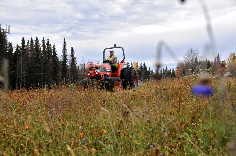
A crew from the Kenai Department of Parks & Recreation works to prepare the Field of Flowers for winter on Oct. 8, 2015. The parcel where the field is located along the Kenai Spur Highway is part of a rezoning plan that has drawn controversy.
