
The Kenai City Council passed its comprehensive plan — a state-required document that gives authority for future land use policies — at its Wednesday meeting. Council members Bob Molloy and Mike Boyle voted against the plan’s final version.
The draft plan presented Wednesday came with 18 suggested amendments from Kenai City Planner Matt Kelley. Most edited informational sections and were adopted unanimously. The only one to provoke disagreement addressed a subject that became central to the evening’s debate: buffers around neighborhoods.
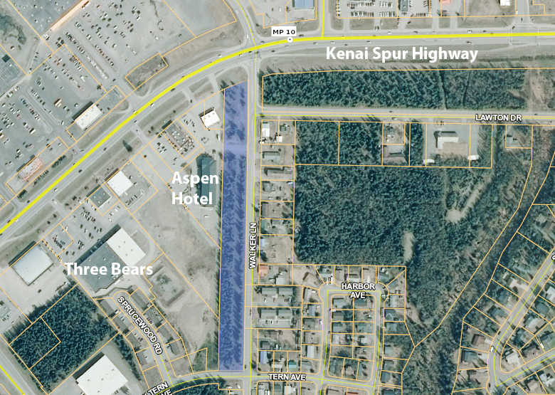
Walker Lane strip
Among the residents who testified were Richard and Kellie Kelso, who during Kenai’s previous comprehensive plan revision in 2013 had been concerned about a wooded strip of city-owned land near their home on Walker Lane.
The 1,368 foot strip of trees separates houses on the east side of the street from the busy commercial center to the west, which includes the Three Bears grocery store, O’Reilly Auto Parts, the Kenai MediCenter and McDonald’s. The Kelsos no longer live on Walker Lane, but said they remain concerned about the neighborhood’s buffer against the commercial area’s light and noise.
The draft 2013 plan would have changed the Walker strip’s land use designation to mixed use, which allows both commercial and residential development. Critics of the 2013 revision — who successfully voted it down 580 to 221 in a ballot initiative that year — claimed proliferation of mixed-use land would lead to commercial sprawl in neighborhoods.
“The 2013 plan didn’t provide protection for neighborhoods, and it looks like the 2016 doesn’t protect neighborhoods either,” Richard Kelso said Wednesday.
Ultimately the 2013 plan gave the Walker strip a parks, recreation and open space (PROS) designation following a successful amendment by council member Terry Bookey at an April 3, 2013 meeting. Bookey, still a council member, was absent from Wednesday’s meeting.
The draft 2016 plan designated the Walker strip general commercial land, but a recommendation in Kelley’s memo would have divided the strip, making only its northern end, near the Kenai Spur Highway, general commercial while preserving the rest with a PROS designation.
This proposal also comes from an earlier iteration of the Walker strip debate. In 2007 Homer Electric Association planned to cut a 25-foot wide path through the trees to lay powerlines for the Aspen Hotel, then newly opened on the west side of the woods. A compromise made the northern section of the property developable and left the rest as a buffer. The dividing line was HEA’s access road and powerline, approximately 376 feet from the strip’s north edge. The Kelsos opposed the split in both 2016 and 2007.
On Wednesday, Molloy moved to designate the entire strip Parks, Recreation, and Open Space.
Council member Tim Navarre disagreed. The Walker strip is among the city-owned properties previously part of the Kenai airfield and now legally dedicated to the airport’s financial benefit through development and leasing.
“The other issue this deals with that we’re not discussing is that this is airport land, and they have a right to be compensated,” Navarre said. “If the city wants to have it be a buffer, there’s an argument that the city has to buy it from the airport so it can turn it into a park or a buffer or whatever.”
Vice-mayor Brian Gabriel ultimately favored designating the entire lot as a buffer.
“If we’re not going to allow development to benefit the airport, the airport should be compensated,” Gabriel said. “But that should be crossed when we get to that point … I think this has been hammered hard enough, and there’s been enough angst over this piece of property. If we’re going to have buffers in one part of it, it makes sense to have buffers in the other part.”
Kenai Mayor Pat Porter favored allowing development on the strip’s Spur-bordering part.
“I understand that people on Walker Lane want to have that property with no development on it,” Porter said. “But if you look at our community, every single part of that highway is very valuable for small business development. And every part of our highway has residential neighborhoods behind it. If we develop this attitude all along the entire highway, we would have no business development at all. That to me is not an attitude that is open for business.”
Molloy’s motion to designate the entire property as parks, recreation and open space failed with a tied vote, with Navarre, Porter, and council member Henry Knackstedt voting against it. In the passed comprehensive plan, the Walker strip is split between general commercial and parks, recreation and open space designations.
Buffer areas
The Kelsos and another public speaker, Carol Freas, said the comprehensive plan should have direct language establishing buffer zones between land uses, especially between neighborhoods and higher-traffic industrial and commercial areas.
Molloy, who in previous debates about airport zoning has advocated for residential buffer zones, proposed re-designating two undeveloped city-owned properties bordering the airport — both drafted as low-density residential — to parks, recreation and open space.
One was a wooded 9.78 acre city-owned lot between the airport and a neighborhood of houses around Sycamore Street — an area where Molloy said he lives, along with buffer advocate Freas. The other was a 19.7-acre property immediately south.
Molloy said the city purchased the property in 2011 on the recommendation of the airport commission to use as airport-residential buffer. Knackstedt, an airport commissioner in 2011, disagreed, saying commissioners hadn’t sought the land for a definite purpose.
“It was not purchased per se as a buffer,” Knackstedt said. “We did not know specifically what its use would be. There’s an advantage to the airport by having its boundaries expand out a little bit … I don’t think we should limit ourselves by changing the land use.”
Both Molloy’s re-designation motions failed with opposing votes from Knackstedt, Navarre, Gabriel, and Porter.
Molloy also attempted to put buffer-encouraging language in the plan’s text. In description of the commercial land use designation, he moved to insert: “Buffers and buffer zones between commercial and adjacent non-commercial uses are desirable.” He also proposed similar statements in the descriptions of the mixed use and PROS designations.
Responding to Knackstedt’s opposing statement that language about buffers would be better addressed in city code where precise definitions could be included, Molloy said the comprehensive plan can establish the principal of buffers, with specifics to be worked out later.
“All this is saying is that they’re desirable,” Molloy said. “It’s a planning concept, not an ordinance.”
Knackstedt moved to change Molloy’s statement in the commercial land use description — that buffers “are desirable” — to “may be desirable.” Knackstedt’s motion failed with Gabriel, Molloy, Boyle and Porter against it.
Similar motions by Knackstedt to modify Molloy’s other statements were successful. Knackstedt said he proposed the “may be” language in Molloy’s commercial land use description for consistency, since Molloy’s proposed addition to the mixed-use description stated that “Use of buffers may be required and is desirable in site layout.”
Knackstedt successfully moved to change that statement to “Use of buffers may be desirable,” with opposing votes from Boyle and Molloy. The altered statement was adopted unanimously, as were Molloy’s changes to the commercial and PROS land use descriptions.
The Kenai Peninsula Borough will now vote on whether to accept Kenai’s comprehensive plan. Alaska statute requires boroughs to maintain comprehensive land use plans, though the Kenai Peninsula Borough delegates this planning responsibility to municipal governments for land within city boundaries.
Reach Ben Boettger at ben.boettger@peninsulaclarion.com.
