Refuge Notebook: Geologists determine age of Bluff Point Landslide
Published 11:35 pm Thursday, August 21, 2014
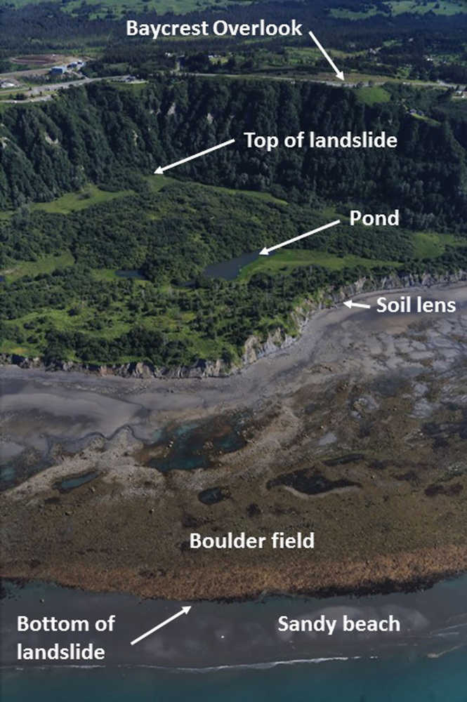


Many Homerites remember when they first came down the Sterling Highway and stopped at the Baycrest Overlook. The view of Kachemak Bay, the mountains and Cook Inlet is totally commanding and can reset a humble traveler’s life priorities in a heartbeat.
Also to be seen, looking west from the Overlook, is an enormous gap in the bluff, now carpeted with grassy meadows, dense alders and spruce, and four small ponds. This mile-wide chasm was made by a massive collapse of the bluff, called the Bluff Point Landslide.
As geologists we try to put a date on everything, even if just to the nearest million years or so. One of us (DR) published a geological report in 1979 with radiocarbon dates of 1,100 and 1,500 years ago on pieces of trees in the deposits overlying the landslide deposits, but those trees could have lived thousands of years after the original slide and then been exposed during more recent, secondary slumping due to beach erosion.
Last summer we had the good fortune to find an intact lens of soil that somehow was transported downhill within the slide without being turned into random debris. The soil lens was exposed for 50 feet along the bluff base by strong wave action during the 2012-13 winter. It showed a crusty black organic layer on top, underlain by several feet of silty-sandy soil that graded downward from dark reddish purple to gray. Several small tree roots stuck out of the soil; a volcanic ash layer was also present. The intact soil-bearing sliver was surrounded by highly deformed slide material. The soil was quite mature, having formed over several thousand years.
Three root samples we sent to the University of California-Irvine were estimated to be about 2,250 years based on radiocarbon dating. We think that is a very good age estimate for the slide because the roots were in growth position and would have died when they were deeply buried by the slide mass.
The full extent of the landslide can only be seen during an extreme minus-5-foot or lower tide, when a sandy beach is exposed beyond the slide boulder field. Many of the boulders exposed at low tide were transported to Bluff Point by a glacial advance that partially filled Kachemak Bay 17,000 years ago.
This glacial expansion is known as the Killey Advance (after the Killey River). Its moraine rested in the Bluff Point area for about 15,000 years, and then was instantly ferried out into Kachemak Bay by the landslide event.
During the past 2,250 years, wave erosion has whittled the slide mass back 400-600 yards, leaving a thick lag of boulders only exposed during low tides. The soil was probably originally deposited as sandy silt in seawater beside the Killey ice lobe because we saw small rocks called “drop stones” in the soil that had been dropped from floating ice.
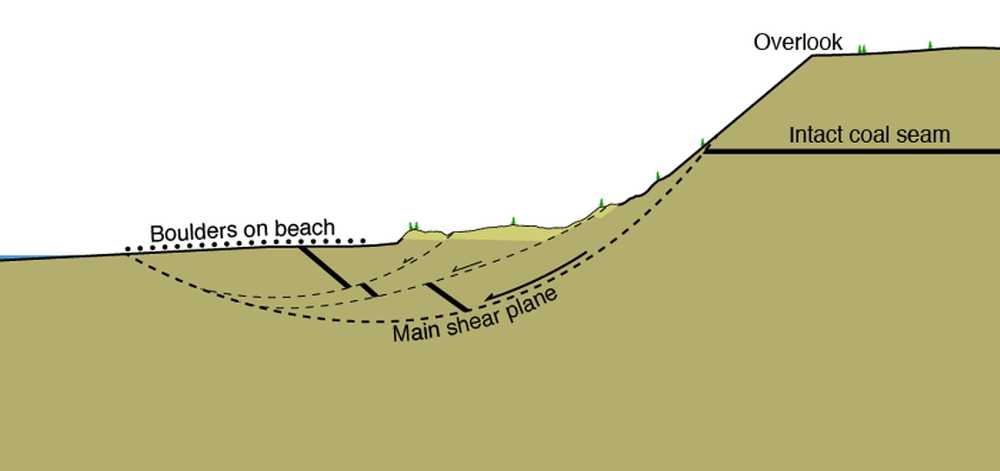
When the bluff collapsed, it probably did not simply drop straight down. Typically in such collapses, a large block rotates downward along a curving failure plane, which is steeply dipping at the top but flattens out below to form a spoon-shaped surface. During failure the outer edge of the sliding block rotates upward, leaving a depression behind it. The four ponds on the Bluff Point Landslide formed in this low area.
Along the beach you can see coal beds tipped up and dipping steeply to the northwest. Farther out during very low tides you can see coal beds dipping in other directions, with some beds overturned where the slide mass was more chaotically deformed. The coal beds are undisturbed in the bluff above the slide, and remain more or less horizontal.
Mapping indicates several landslides around Bluff Point. Looking at GoogleEarth you can see a 2.7-mile strip extending on both sides of the main slide with collapse deposits at the bluff base. In July 2009, between Bluff Point and Diamond Creek, the high bluff face collapsed like a hammer onto the upper end of an old slide block, rotating the block like a teeter-totter and pushing up a very strange 15-foot-high mound in the intertidal zone for a distance of 1,200 feet along the beach. Rotated shale layers in the mound’s center were nearly vertical. Over the following winter the mound was completely removed by wave erosion.
People were living in Kachemak Bay when the Bluff Point Landslide occurred 2,250 years ago. The Marine Kachemak Tradition culture had already been here for 800 years and would be here for another 1,000 years. The dumping of so much sediment into the Bay must have disrupted fish and sea mammal populations. It would be interesting to examine the rich legacy of artifacts left by those people to see if there is any cultural expression of this event.
The Bluff Point Landslide was likely triggered by a large 1964-style subduction zone earthquake. Ian Sheenan of Durham University (UK) and his colleagues dated five major pre-1964 earthquakes over the last 3,000 years, two of which occurred 2,140 and 2,415 years ago. There are typically errors of 100-200 years with radiocarbon dates, so either earthquake could have been culpable.
Dr. Berg retired as the ecologist at the Kenai National Wildlife Refuge in 2010. Dr. Reger is a consulting geologist who retired from the Alaska Division of Geological & Geophysical Surveys. Dr. Higman is a geologist with Ground Truth Trekking.