
There are myriads of ways to measure and describe an area, but as they say, “a picture is worth a thousand words.” At work I frequently use Google Earth to look at remote locations of interest. As you zoom in, the clarity or resolution is impressive considering the image was taken from a satellite about 300 miles above the earth.
Actually calling it an image is incorrect. With each sensor the satellite observes a small area called a pixel, one at time. The sensors sweeps back and forth recording row after row of pixels, which are later compiled to create an “image.”
This technology is different than a digital camera which contains an array of millions of photosensors (one for each pixel) to capture the whole picture in just one click. The ability to repeatedly image large areas of our planet in great detail makes satellites a remarkable tool. Unfortunately, that technology comes at a cost, one that is prohibitive for small projects.
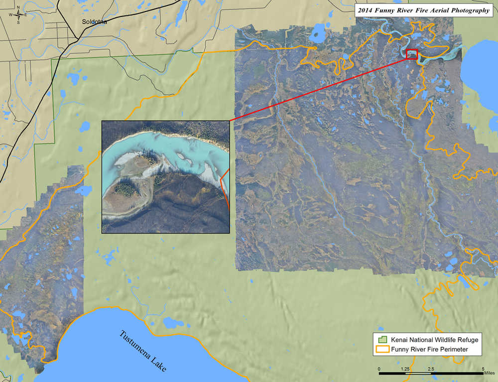
Last year, after the Funny River Fire was officially out, we were able to start assessing the effects the 200,000-acre fire had on the landscape. Fire is a powerful natural disturbance that can bring about great destruction but also great ecological benefits. This fire created a striking visual mosaic as it burned through the patchwork of ecosystems. Flying over the burned area a few months later revealed the landscape as a medley of blackened forests, islands and fingers of vibrant green, blue water, and some amazing hillsides of fireweed in full bloom. It was quite beautiful, and I was itching to photograph it. Not just a handful of critical areas, but the whole thing!
A few years ago, Nikon came out with a 36.6 megapixel camera. In the steady progression of camera resolution, this might not seem revolutionary, but the size was just large enough to change the whole Do-It-Yourself aerial photography game. With the larger format it was possible to take a photo from a safe altitude, with good resolution, and get a 3,000-foot field of view.
Compiling adjacent images into an even larger image is called a mosaic. To create a seamless mosaic, the pictures need to overlap about 60 percent. With the new camera we would need to fly flight lines about 1,500 feet apart. With my older 12.2 megapixel camera, my flight lines needed to be 500 feet apart. That proved difficult to fly consistently, time consuming, so the new camera changed everything.
Capturing the photos is just one part of the process. I calculated it would take about 10,000 photos with my little camera to do the whole job. The final image also needs to be geometrically corrected so you can view it in something like Google Earth. This ensures everything has the correct position and is not distorted. The final image is called an orthophoto.
With new cameras available, some of my colleagues along with Dr. Matt Nolan from the University of Alaska Fairbanks started using a process called Structure from Motion (SfM) to mosaic large areas with great results. The process actually builds a three-dimensional structure from two-dimensional pictures. The three dimensional model allows for better orthophotos and the creation of high resolution contour and surface maps. For many applications, the three dimensional structure is more valuable than the orthophoto, but now we can have both.
It was October by the time we had our system all together and mostly bug-free. Short day lengths gave us about three good hours a day to photograph. The weather was also starting to turn and the threatening snow would put an end to the project for the year. So we had little time to run complete tests if we wanted to cover some of those 200,000 acres.
With refuge pilot-biologist Nate Olson, our first real test flight was a three hour gamble (that it would work) over 45,000 acres in the northeast corner of the burn. After landing I nervously looked at one of the 1,800 photos we took, and was relieved to see a clear stunning photo. In two more days we were able to capture another 3,300 photos, for a total area of 110,000 acres in less than eight hours of flying.
Processing the photos took my computer about a week to churn through, but it works 24/7 for cheap. The resolution of the final orthophoto was about three times that of a commercial satellite image. You can experiment with creating mosaics and three dimensional models yourself through several websites like https://photosynth.net.
The snow finally came, ending the project for the year, but come this May we should quickly capture the remainder of the burn. Fire ecologists and biologists will use the imagery for assessing and monitoring the burn area. With the low acquisition cost, we have plans to use the technology for landcover mapping, habitat change detection, structure and community protection, counting animals, and measuring snow depths.
Mark Laker is an ecologist and database manager at Kenai National Wildlife Refuge. Find more information at http://www.fws.gov/refuge/kenai/ or http://www.facebook.com/kenainationalwildliferefuge.
