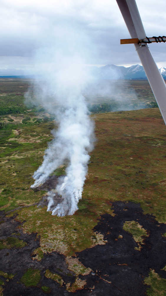
I flew over much of the Funny River Horse Trail Fire this past Monday. Almost three weeks after the fire was first detected on May 19, 60 per cent of the perimeter has now been contained. On this particular day, there were two actively burning areas high on the Tustumena Bench, torching alpine tundra and subalpine shrub.
What struck me the most was how much forest had NOT burned within the perimeter outlining the almost 200,000-acre fire footprint. Sure, there were black spruce stands that had been completely incinerated down to black ash, particularly in the area close to the public eye along Funny River Road and across from the Kenai Keys. But there were other areas of mixed forest where the fire had skipped over the hardwood as it spotted from one white spruce to another. There were hardwood stands where the fire had burned through rapidly, consuming grass and other flash fuels on the ground while leaving the aspen canopy intact. As our plane approached the rugged hills above Tustumena Lake, we flew over extensive stands of white spruce and hardwood left unscathed within the fire perimeter.
What the fire folks will tell you is that oxygen, heat and fuel are needed to make a fire. Well, we had plenty of oxygen in the first few scary days of this fire with sustained winds of 20 mph and gusts exceeding 30 mph. We had heat provided in the form of human-caused ignition in extremely dry conditions.
It’s the fuel that is a bit more difficult to describe. Of the almost 200,000 acres that the fire perimeter encompasses, 88% is (or was) forested. Analysis of Landsat satellite imagery tells us that the forest was composed of white spruce (68,300 acres), black spruce (54,200 acres), mixed hardwood-softwood (46,800 acres), mixed conifer (1,200 acres), hardwood (4,500 acres), and mountain hemlock (500 acres). Lakes, wetlands, shrub and alpine tundra constitute the remaining area.
Some think the fire raged because of the unsalvaged beetle-killed white spruce on the Kenai National Wildlife Refuge. Indeed, aerial surveys conducted by the Alaska Forest Health Protection Program indicate that about 50% of the area within the perimeter had been injured or killed by spruce bark beetle, mostly during the 1990s. This agrees well with satellite imagery that shows about the same acreage in white spruce and mixed forest.
But, again, this doesn’t necessarily distinguish what burned or didn’t burn in this fire. One of our refuge biologists, Matt Bowser, using an algorithm in MODIS, which is the same multispectral satellite imagery used to estimate the fire perimeter, estimated that only 65 per cent of the 200,000 acres actually burned. Of the area that burned, only about 26,000 acres constituted “high severity” with the remaining 100,000 or so acres burned categorized as “low severity”. And much of the area that burned hot was, in fact, mature black spruce, not beetle-killed white spruce.
The fire footprint was better defined by the “ghosts of fires past”. Dr. Ed Berg and Andy DeVolder, both previously on our staff, used carbon-14 dating of charcoal and tree-ring dating of fire-scarred trees to map historic fires on the refuge. The current fire burned over mature forest that was either not known to have burned in the last 200 years or regenerated in the aftermath of the 1871 fire that burned onto the Tustumena Bench. The 2009 Shanta Creek Fire burned 13,000 acres of the latter.
Much of the perimeter of the Funny River Fire was fated to be defined by previous burns including the 2005 King County Creek Fire and 2007 Swan Lake Fire that bump up against Skilak Lake, and the 2004 Glacier Creek Fire along the northeast corner of Tustumena Lake. Over in the west, the fire perimeter is as much defined by the 1981 Slikok Lake Fire as it is by the utility corridor along the Sterling Highway.
Just as previous fires helped define the current fire, the Funny River Horse Trail Fire will have an ecological and economic legacy that will extend into the future, past most of our lifetimes. Black spruce has a historic mean fire return interval of 80 years; white spruce has a return interval of several hundred years. The communities of Kasilof, Soldotna, Sterling and Funny River, so recently threatened by this fire, are now somewhat protected from future wildfire, at least from those originating between Skilak and Tustumena Lakes. Spruce stands that burned hot enough to reach mineral soil should convert to early successional hardwood, setting the stage for good moose hunting 15 or 20 years down the road.
The downside is that this fire is only a small section of the rapidly-developing urban interface that stretches for 175 miles along the refuge boundary between Point Possession in the north and the Fox River in the south. Refuge fire managers will continue working with landowners and other agencies to strategically reduce fuel loads along this wildland-urban interface to help ensure that future wildfires can renew wildlife habitats on the refuge without damaging our communities.
John Morton is the supervisory biologist at Kenai National Wildlife Refuge. You can find more information about the refuge at http://kenai.fws.gov or http://www.facebook.com/kenainationalwildliferefuge.

