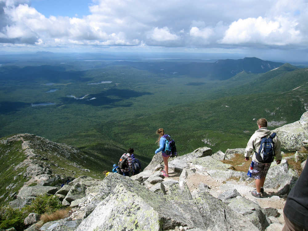
BAXTER STATE PARK, Maine — I don’t remember much about my climb up Mount Katahdin 25 years ago. I was young and fit. It was no big deal. But my second climb is etched in my middle-aged mind with twinges of pain, fear and a big dose of humility.
My husband and I started our hike up Mount Katahdin on a nice August day last summer around 8:30 a.m. We soon met people coming down the mountain, and wondered how they’d reached the peak so early in the day. Turns out they hadn’t gone far. They turned around when they realized how tough the climb up Katahdin is.
Katahdin, located in Baxter State Park, is the tallest mountain in Maine — nearly a mile high, 5,270 feet (1,606 meters). But it’s not just the physical challenge that makes Katahdin so challenging — though the relentless scramble over boulders without obvious footholds or handholds is exhausting.
And it’s not just the distance in miles — our trail, Hunt Trail, was over 10 miles (16 kilometers) round-trip, or the scale of ascent (4,188 feet — 1,276 meters — in elevation gain). It’s not even the unpredictable weather, though that nice summer day we started with turned to rain, hail and 40 mph (64 kph) winds atop the mountain.
It’s the psychological aspects that are so daunting: fear of falling if you lose your grip on a tiny iron rung in a stone wall with a sheer drop below, fear of getting stuck in a crevice. And we didn’t even do Katahdin’s infamous Knife Edge, a narrow ridge with drop-offs on either side.
Our biggest problem was time. On city streets, I can walk 3 mph (4.8 kph). On Katahdin, climbing gingerly up an irregular course of sharp-edged boulders, fighting winds on exposed rock face, I averaged under a mile an hour (1.6 kilometers). The hike I thought would take eight hours took 11½.
When we set out, a ranger asked if we had a flashlight. I’d nodded yes, but really I only had a cellphone flashlight app. We never imagined we’d be hiking after sunset. Fortunately, I’d shut the phone down to save battery power, so the app held out. We were lucky to be in flat forest by then. It would have been impossible scrambling down Katahdin’s granite blocks in pitch-black wilderness, one hand holding a phone.
Do I regret last summer’s climb? Of course not. We considered turning back at times and got panicky after dark. But to have done it as a feckless 20-something and again as an out-of-breath 50-something whose muscles ached for days taught me that you don’t necessarily get smarter with age — just creakier. Mother Nature even celebrated our middle-age triumph with a rainbow sighting from the top.
For others considering a climb, regardless of age, here’s my hard-won advice. Bring a headlamp for lighting up the dark. Wear hiking boots or trail runners; our sneakers were slippery on the rocks. Wear sunscreen, bring water and food, and be prepared for rain, wind and cold. Baxter Park has recorded 47 fatalities since 1962, 20 of them above the tree line — including falls, lightning strikes and cardiac arrest. Rescues are exceedingly difficult here and help is hours away. Park director Jensen Bissell says at least once each summer, someone sits down on the trail in the dark and waits until morning to get out.
Drive up the night before. Reservations for campsites, motels and parking go fast. Rangers start giving away reserved parking spots at 7 a.m. We got the last parking spot for Hunt Trail at 8 a.m. on a weekday.
Research your route. There are a half-dozen trails up Katahdin. The mountain’s peak is the northern terminus for the Appalachian Trail, which begins in Georgia, and the trail we picked coincides with the Appalachian Trail. We got to watch as hardy hikers who’d started through-hiking months earlier completed their triumphant homestretch here.
When we finished, we were dazed — hungry, exhausted, everything hurt. As we drove along dark country roads from Baxter Park to our vacation house in central Maine, I looked out the window and saw the Big Dipper so bright and low in the sky it seemed close enough to touch.
My husband started to pull over for a look when an enormous moose emerged from the darkness, as if in a dream, loping across the road into our headlights. We sped up and passed it with inches to spare. The close call was a fitting end to a long day in the Maine wilderness — a day that made me grateful, for many reasons, to be alive.

