Moose continue to be one of the most valuable species that reside on the Kenai Peninsula. They trigger an emotional response from most folk and can consistently be viewed by residents and visitors at any time of the year. Highly prized by hunters and wildlife watchers, feared by motorists, and often despised by gardeners, moose have sparked enormous interest by wildlife managers and researchers over the years.
For the past several decades, the tool of choice for moose researchers in Alaska has been radio collars and, in recent years, GPS collars. These devices allow researchers to pinpoint an individual moose’s location at just about any time and allow for the in-depth analysis of moose movement over time. There are many challenges related to affixing a collar around the neck of a gigantic wild animal. One can’t simply walk up to a wild moose and strap a collar on it without potentially serious repercussions. Our solution is to use helicopters.
Capturing a moose from the air is a well-coordinated event that can be loosely compared to a well-choreographed episode of “Dancing with the Stars.” Several skilled biologists and pilots are needed to pull it off and the resulting sequence of events is graceful to watch. Once the target moose is identified from a spotter plane, a helicopter swoops in so a biologist can dart the animal with an immobilizing chemical cocktail that will eventually sedate the animal. The spotter plane circles overhead to monitor the drug’s effects and ensure the moose avoids any potentially deadly situations such as creeks or lakes.
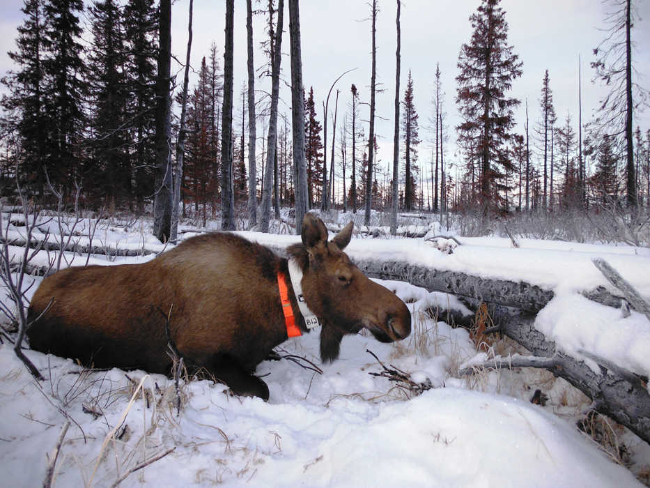
Once the drugs take effect and the animal is immobilized, the helicopter returns with a team of biologists to “process” the animal. Typically this involves fitting a radio collar, taking measurements, and collecting blood or fecal samples. An antagonist or “reversal” drug is then administered which counteracts the effects of the immobilizing drugs and the moose is sent on her merry way. Then it is on to the next subject.
During this past month, the Kenai National Wildlife Refuge, in cooperation with the Alaska Department of Fish and Game, successfully captured 30 moose using these methods in Game Management Units 15A and 15B. The goals of the two agencies were the same, to capture a specified number of moose and fit them with GPS collars, but how we will use the data differs.
ADF&G will use the GPS data in two ongoing moose studies. The purpose of the first study is to collect and analyze baseline data on seasonal body condition, productivity, and movements of moose in response to intensive management in GMU 15A. The purpose of the second ADF&G study is to evaluate how moose respond, both physiologically and behaviorally, to daily and seasonal fluctuations in environmental temperatures. Biologists will evaluate how wild moose select habitat based on thermoregulatory costs in different successional stages of the boreal forest, one in recently-burned areas and the other in mid- to late-seral stages. These data will ultimately allow managers to identify areas that can provide both thermal relief and adequate forage for moose during seasonally warm temperatures when planning habitat improvements for these populations.
At the Kenai Refuge, we’ve grown increasingly interested in recent years about how moose may be using residential areas on the central peninsula. We all see moose feeding along our roads during winter and calving in our neighborhoods in the spring. Much like moose in Anchorage, there is anecdotal evidence that some moose may spend most if not all of their life cycle within urban areas. On the other hand, we know that some moose may use residential areas as relatively safe places to spend their winters or drop their calves, but only seasonally, choosing to spend most of their life cycle on the Refuge. So we will use the GPS collar data to assess moose behavior, movement, and habitat use along the urban interface.
In addition, several moose were collared close to the Sterling Highway, east of Sterling, within the Refuge. We are interested in assessing moose movements in advance of road improvements that are scheduled to begin this summer on the 22-mile section of the highway that runs from Sterling to Jim’s Landing (MP 58-79). Collecting pre-construction data will allow us to better evaluate the post-construction success of culverts, fencing and a bridge being built to guide and facilitate wildlife crossing the Sterling Highway.
The collaborative nature of this study allows Federal and State biologists to reduce the costs of research while sharing data. And just maybe the bright orange collars hanging around the necks of some Kenai moose will make them a bit more visible and prevent a vehicle collision or two.
Nathan Olson is the wildlife biologist-pilot at Kenai National Wildlife Refuge. Find more about the Refuge at http://kenai.fws.gov or http://www.facebook.com/kenainationalwildliferefuge.

