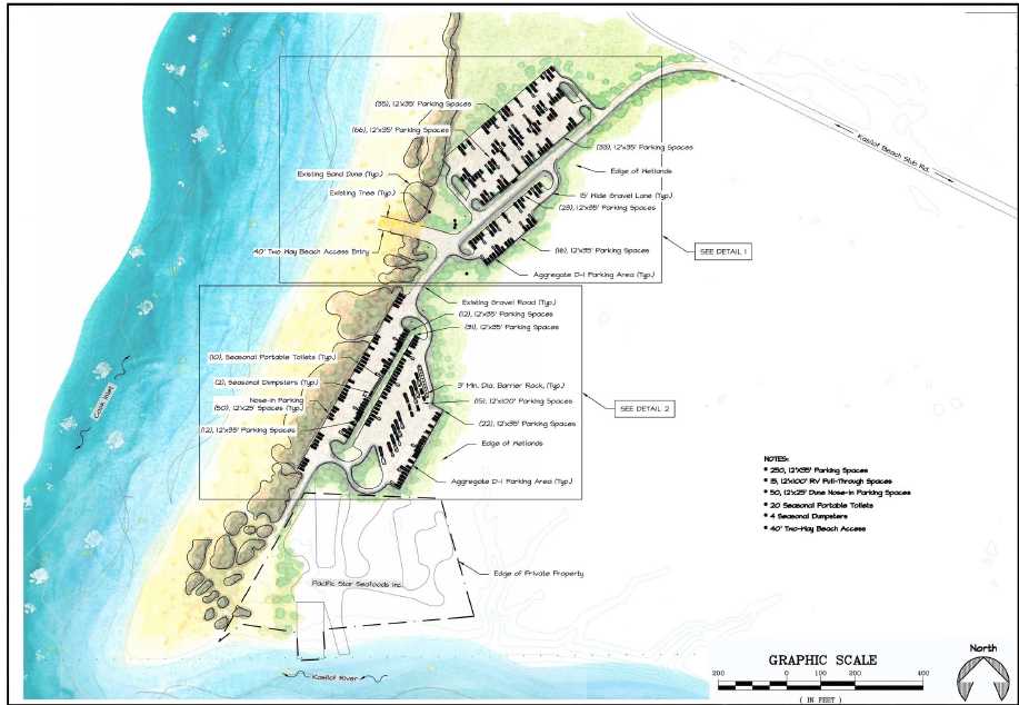
The Alaska Department of Natural Resources is seeking public comment on the site plan concept for a parking lot near the mouth of the Kasilof River.
The lot would provide more access to fishermen in the Kasilof River Special Use Area. The zone, designated a special use area in 2011, encompasses the river mouth and a stretch of coastline from approximately a mile north of the river mouth to approximately two miles south. The area also extends to approximately mile 3 of the river.
The proposed parking lot would have room for 315 vehicles, including a turnaround for large vehicles and trailers and a spot for 20 temporary restrooms and four seasonal Dumpsters. The development plans include a 40-foot wide, two-way vehicular beach access as well.
The personal-use fishery has grown in the past decade. The number of household days fished with dipnets — the combined total number of days individuals with personal use permits fished — has more than doubled in the past decade, climbing from approximately 4,600 to more than 10,200, according to the Alaska Department of Fish and Game’s records.
The growth in use and concern of overcrowding spurred the DNR to implement the special use area regulations. The regulations set up a management plan to still enable access while protecting the plants and fish in the area, according to the original designation from 2011.
The DNR’s Division of Mining, Land and Water has been planning to develop the land on the north side of the river mouth since 2013, when planners submitted proposals for capital improvement projects on the site.
The department already received funding in two phases of $1.4 million each, targeted at developments on both sides of the river, said Christy Colles, a natural resources manager with the DNR’s Division of Mining, Land and Water’s Southcentral Regional Land Office. The real costs will be evaluated later, she said in an email.
“Projected costs are not available at this time since the project is at the preliminary level of design,” Colles said.
The state owns land on both the north and south sides of the river mouth, but only the north side is practical for development at present, according to the DNR’s project description.
The department is also in the planning phase for a boat retrieval system on the lower Kasilof River. Most users currently launch from the Kasilof River State Recreation Site at Mile 7.5 of the river, where the Sterling Highway intersects with it. However, there is no public boat retrieval system further down the river, which has raised concerns.
The vast majority of river users who responded to an October 2011 DNR survey said they prefer drift boat fishing on the Kasilof, and most said they utilize the lower river from the Sterling Highway bridge to the lower river.
The DNR acquired several land parcels on the lower river for the purpose of installing a boat retrieval system in 2015. The Division of Parks and Outdoor Recreation is in the planning phase for the boat retrieval system, Colles said.
However, the project is separate from the north beach development. At present, the department is only seeking submitted comments, Colles said.
“At this time the department does not plan to conduct public meetings,” Colles said.
The public comment period will close Nov. 30. Those who wish to comment on the plan can send a letter to 550 West 7th Ave., Suite 900c, Anchorage, AK, 99501 or emailing Adam Smith at adam.smith@alaska.gov or Christy Colles at christianna.colles@alaska.gov.
Reach Elizabeth Earl at elizabeth.earl@peninsulaclarion.com.

