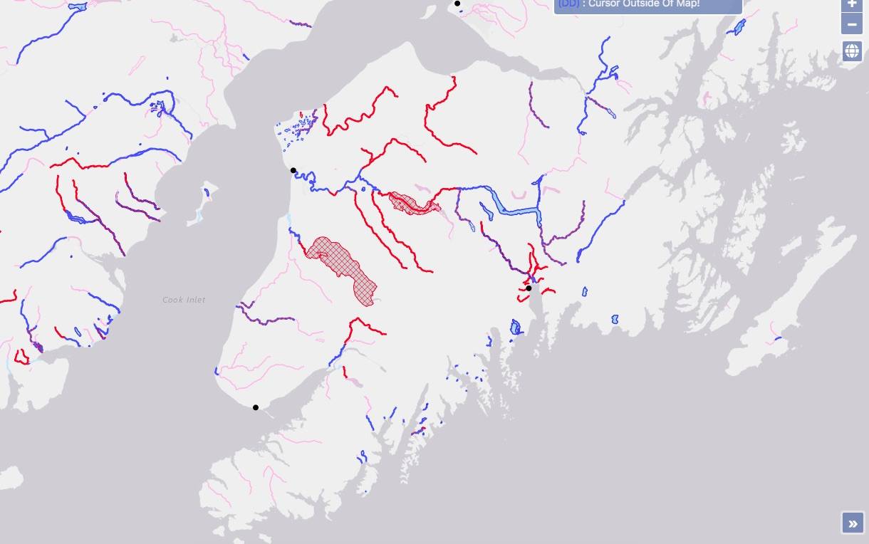
A DNR map of navigable and non-navigable waters are seen on the Kenai Peninsula. (Screenshot)

A DNR map of navigable and non-navigable waters are seen on the Kenai Peninsula. (Screenshot)

State unveils maps in effort to ‘unlock’ Alaska waters

The maps are part of an initiative to assert control of state lands.

The State of Alaska has management rights in some, but not all, of Kenai Peninsula waters. That’s according to new maps published by the Alaska Department of Natural Resources last week, which plot which Alaska waters are “navigable” and therefore under state, rather than federal, management.

The maps are the result of Gov. Mike Dunleavy’s “Unlocking Alaska,” initiative, which was announced earlier this year, and has a stated goal of establishing a state website people can use to see where they can “freely travel.” Tustumena and Skilak Lakes, for example, are part of the Kenai National Wildlife Refuge created by the Alaska National Interest Lands Conservation Act of 1980 and are shown as “not navigable” on the new maps, meaning they are not under state control. Most of the Kenai River, in contrast, is shown as “navigable,” meaning it is under state control.

States’ ownership of the beds of navigable waters located within their boundaries can be traced back to the U.S. Constitution’s Equal Footing Doctrine, which says new states entering the union would be able to do so on the same footing as the original 13 colonies already in the Union. When Alaska became a state, it opted to defer management of these waters to the federal government while Alaska was still new to the United States.

Though the Equal Footing Doctrine means navigable waters belong to the state, efforts to reassert state management of those waters have accelerated in recent decades.

Alaska began to reassert its control over some state lands after being asked to prove that those lands had historically been used for travel.

Transportation corridors cannot be closed off to public access by the federal government.

The state expanded its efforts to include navigable waters that may be exempt from federal control. Navigable waters are those which — at the time of statehood — were used or susceptible to being used in their ordinary condition as a highway for commerce over which trade and travel were or could have been conducted in ways customary at the time. Alaska plans to press claims on other waters in the future.

“Any attempt by federal authorities to issue citations or harass Alaskans who are legally using these waters will be met by litigation from the state of Alaska,” the March press release said.

To figure out which waters meet those guidelines, the Alaska Department of Natural Resources’ Public Access Assertion and Defense (PADD) unit conducts scouting expeditions. Those efforts are led by PADD Unit chief Jim Walker.

The Department of Natural Resources’ interactive map can be accessed at mapper.dnr.alaska.gov/map.

Reach reporter Ashlyn O’Hara at ashlyn.ohara@peninsulaclarion.com.
More in News

Alaska State Troopers logo.
Troopers seek help finding man wanted on felony warrants

Tanner Allen Geiser was last seen Thursday in Nikolaevsk near Anchor Point

From left: Joseph Miller Jr. and Jason Woodruff, Alaska State Troopers charged with felony first-degree assault, appear with their lawyers, Clinton Campion and Matthew Widmer, for an arraignment at the Kenai Courthouse in Kenai, Alaska, on Thursday, Nov. 14, 2024. (Jake Dye/Peninsula Clarion)
Troopers renew not guilty pleas after grand jury indictment

Woodruff, Miller charged with felony first-degree assault for alleged conduct during May arrest in Kenai

Canna Get Happy owner Sandra Millhouse, left, appears with attorney Richard Moses during a meeting of the Board of Adjustment at Kenai City Hall in Kenai, Alaska, on Oct. 15, 2024. (Jake Dye/Peninsula Clarion)
Kenai board of adjustment denies Canna Get Happy appeal

The owner sought to operate a retail marijuana establishment at Swanson Square in Kenai

A winter weather advisory and special weather statement are in effect for the western Kenai Peninsula, while other messages are published for the eastern Kenai Peninsula, in this map from the National Weather Service. (Screenshot/National Weather Service)
Snowfall, heavy winds forecast for tonight

Winter weather advisory and other messages from National Weather Service effective through Friday morning

The storefront of Madly Krafty in Kenai, Alaska, is seen on Thursday, Nov. 14, 2024. (Jake Dye/Peninsula Clarion)
Soldotna Chamber of Commerce holds 5th annual Spark event

Soldotna sharks give $4,000 scholarship to local gift shop

Kenai Peninsula Borough School District Superintendent Clayton Holland speaks during a meeting of the KPBSD Board of Education in Soldotna, Alaska, on Monday, June 3, 2024. (Jake Dye/Peninsula Clarion)
School board considers ‘hypothetical’ 4-day calendar, asks for community survey

Included in the work session notes is a potential calendar describing weeks running from Monday to Thursday starting in August 2025

Commercial fishers speak to the Commercial Fisheries Entry Commission during a public hearing on a proposed regulation change to add dipnets to the east side setnet fishery at Cook Inlet Aquaculture Association in Kenai, Alaska, on Saturday, Nov. 2, 2024. (Jake Dye/Peninsula Clarion)
CFEC hears from setnetters on dipnet proposal at Kenai hearing

The CFEC gave emergency approval to the gear in May but decided in June not to approve dipnets as permanent gear

Signs and supporters line the Kenai Spur Highway in Kenai, Alaska, on Tuesday, Nov. 5, 2024. (Jake Dye/Peninsula Clarion)
Local races unchanged after 1st major update of election results

The additional votes represent early ballots that were cast ahead of Election Day but after an Oct. 31 deadline

tease
Man arrested for 3 shooting incidents at reproductive clinic, recovery org

Homer’s Kachemak Bay Family Planning Clinic was targeted twice Monday

Most Read