After this last summer’s lightning, fires and long drought, it should be obvious that our local climate is becoming warmer and drier than longtime residents may remember. Since the last big drought in 1968, which led to the 1969 Swanson River Fire, available water on the western Kenai Peninsula has declined 62 percent!
Water temperatures in Anchor, Funny and Ninilchik rivers, and in Beaver, Crooked, Slikok and Soldotna creeks, reached or exceeded the values forecasted by Sue Mauger, with the Cook Inletkeeper, for 2069 — 50 years into the future. It hit 80 degrees on the Deshka River in the Matanuska-Susitna valleys! Climate change is alive and well.
These are all nonglacial streams, meaning that they don’t receive the refrigerating benefits of glacial input. The largest nonglacial stream on the peninsula is the Anchor River, which presumably receives its waters from precipitation, groundwater and the surrounding peatlands.
A 2015 article authored by Mike Gracz of the Kenai Watershed Forum showed what the relative contribution of those sources might be. Using two methods, Gracz and his colleagues found that 55 percent of dry season flow in Limpopo Creek, an Anchor River tributary, originated from adjacent peatlands. Peat stores water well and so buffers against dry seasons and drought.
But nonglacial streams are experiencing multiple stressors. Hotter summers warm these streams, while spruce bark beetles, green alder sawflies (an exotic species) and wildfire consume the riparian vegetation that shades their waters.
To add salt to that open wound, peatlands, which store water like a giant sponge, are drying. Ed Berg, former ecologist at Kenai National Wildlife Refuge, and his colleagues found that wetlands in the Kenai Lowlands lost 6% to 11% of their surface area per decade since the 1950s.
Almost 520,000 acres of the Kenai Lowlands are peatlands. Slightly more than half of peatlands on the peninsula fall within Kenai National Wildlife Refuge. Although they are typically 3 to 21 feet deep, peatlands are often disguised by the growth of woody shrubs and black spruce, a telltale sign that they are drying.
Underneath, less obvious to the untrained eye, many organic soils originally mapped as undecomposed (fibric) in the early 1970s were mapped in the early 2000s as partially decomposed (hemic). Increased decomposition is a sign that oxygen is more prevalent because the soils are drying out.
Even as nonglacial streams are reaching lethal temperatures for salmon because of a warming climate, an effect exacerbated by loss of shade and the loss of groundwater from drying peatlands, the drying peatlands themselves are making the climate warm faster.
Peatlands cover only 3 percent of the global land surface, but they store 42 percent of all carbon — more than the world’s forests. And healthy peatlands act as carbon sinks. According to the International Union for the Conservation of Nature, they sequester 0.37 gigatons of carbon dioxide annually.
But as peatlands dry and the organic matter that has accumulated over millennia begins to decompose, the stored carbon is released into the atmosphere.
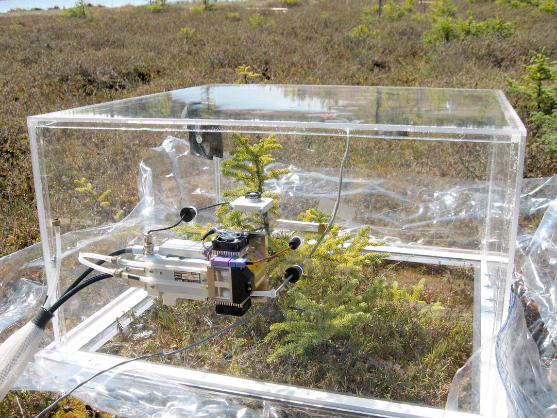
Sue Ives, a former graduate student at Alaska Pacific University, measured carbon dioxide exchange in a Swanson River peatland on the Kenai refuge in 2008-09 using a portable acrylic chamber fitted with an infrared gas analyzer.
Her study showed that while Sphagnum and sedge peatlands ranged from net carbon sinks to approximately carbon neutral, peatlands with woody vegetation were carbon sources. In fact, on a gram per square meter basis, more carbon was potentially released from drying peatlands annually (182 g) than was captured by healthy peatlands (133 g).
Worldwide, the International Union for the Conservation of Nature estimates damaged peatlands contribute the equivalent of almost 6% of carbon dioxide emissions from human activities.
This is definitely a wicked problem, but perhaps with a simple solution. Many scientists suggest that peatlands not only be conserved but be restored. On the Kenai Peninsula, restoration in most cases may simply be “rewetting” peatlands that are drying out in our warming climate.
And nature’s best hydraulic engineers are beavers.
I read a fascinating study published in the Journal of Hydrology in 2015. Two scientists at the University of Buffalo used a groundwater flow model to simulate the effects of a beaver dam on the hydraulic head and discharge to peatlands adjacent to a small pond in New York.
Construction of a beaver dam increased groundwater discharge rate from the impounded pond by 70% to 90% depending on whether an underlying clay layer was present or not.
The takeaway message here is that while more beaver ponds may not completely mitigate for the cascading effects of a warming climate, they may really help to sustain at least some peatlands.
Healthy peatlands mean less atmospheric carbon and, perhaps more to the point for many of us, continued groundwater flow into nonglacial anadromous streams during critically dry periods of the summer. In this instance, more beavers may mean more salmon.
And here’s one more perk if that’s not enough for you. Peatlands in the northern Kenai Lowlands have historically served as natural firebreaks to contain the big fires in 1947 and 1969. But it was so dry this summer that fire did encroach into the big peatland that served as the western boundary of the Swan Lake Fire north of the Sterling Highway.
Keeping those wetlands wet may be in our best interest.
Dr. John Morton is the supervisory biologist at Kenai National Wildlife Refuge. Find more Refuge Notebook articles (1999–present) at https://www.fws.gov/refuge/Kenai/community/refuge_notebook.html.

